
For almost two years I have been working with the cartographers at National Geographic on a series of new Pacific Crest Trail maps and they are now ready, just in time for the 2020 hiking season.
The new National Geographic PCT Maps are 11 map booklets, each one covering about 240 miles of trail. The booklets weigh about three ounces each (between 2.8 and 3.2 ounces to be exact) and are printed on waterproof, tear-resistant material.

Each Pacific Crest Trail maps weigh between 2.8 and 3.2 ounces.
Maps can be purchased from the Pacific Crest Trail Association online store or other National Geographic Map retailers.
These maps are the result of a partnership between the Pacific Crest Trail Association, National Geographic Maps and the Halfmile Project. National Geographic Maps is now a new PCTA corporate partner providing financial support for the trail.
Here are a few samples of what the new PCT maps look like:

The Pacific Crest Trail in Southern California from the Sunrise Trailhead to Scissors Crossing.
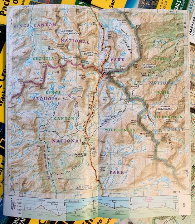
Forester Pass in the Sierra Nevada, the highest point on the Pacific Crest Trail.
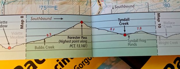
Each map page has an elevation profile of the trail.

Crater Lake National Park Oregon, showing the Rim Trail alternate that most Pacific Crest Trail hikers will walk.
I’ll have a more detailed blog post about this soon, but one interesting thing for Pacific Crest Trail hikers is the availability of the National Geographic PCT Maps in several smartphone apps such as Gaia GPS. Having matching printed maps and smartphone maps is a very powerful combination for hiker navigation.

The Pacific Crest Trail in Southern California from Sunrise Trailhead to Scissors Crossing on my iPhone in the Gaia GPS app. Compare this to the photo of the printed map above.
Note: No matter how good navigation apps may be, hikers should always carry printed maps. These new lightweight PCT map booklets make that easier than ever.
When I first started hiking the Pacific Crest Trail with a Garmin GPS in 2007 I had no idea what Halfmile’s PCT maps would eventually become or how technology would change. Many tens of thousands of hikers have downloaded Halfmile maps and successfully used them to hike the Pacific Crest Trail.
Over the years, many hikers have helped make Halfmile’s PCT maps better with updates, comments, and suggestions. I am especially appreciative for the months of work by Afloat, Crop Duster, David “White Jeep” Lippke, Tina Lippke, Dal Brandon, Dormouse and Dirt Stew, who spent thousands of hours creating new technology, helping log trails, editing maps and other information about the Pacific Crest Trail.
Halfmile’s PCT Trail Notes and GPS data will continue to updated — look for 2020 updates on this web site in January. The old Halfmile map PDF files are no longer being updated and have been removed from this website.
Disclosure: I make no money from PCTMap.net, National Geographic, or being Halfmile. At one time this web site was supported by hiker donations, but I stopped accepting donations in 2013. I encourage those who can to support the trail by donating to the Pacific Crest Trail Association.
-Halfmile
